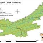
The Nescopeck Watershed, Luzerne County, Pennsylvania, has its share of mine scarred lands, but the most evident legacy of coal mining is the water pollution that flows into its waterways. As reported by the federal list of impaired waters (aka. 303(d) List), there are 218.75 total stream miles in the watershed, 55.38 miles are impacted by abandoned mine drainage. Streams Impacted by Abandoned Mine Drainage are as follows:
Nescopeck Creek, Little Nescopeck Creek, Cranberry Creek, Stony Creek, Black Creek and Oley Creek
These streams have been the center of many studies completed on in the Nescopeck Watershed in the Eastern Middle Anthracite Coal Field. The Jeddo Tunnel, both an engineering marvel in its time and curse in the present day has also been the focus of many studies since its inception in 1890. There is debate that it could possibly be the largest abandoned mine discharge (based on flow) in Pennsylvania rivaling the Old Forge Borehole which flows in to the Lackawanna River near Scranton. The highest recorded discharge was read from the weir as 157,000 gpm on March 31, 1940 at 7 a.m. Hazleton had seen a rainfall total 7.77 inches that month more than double the 30 year average rainfall for that month (Ash 1950).
There are a total of 11 major abandoned mine discharges (table 1) with a total iron yield of 887,813 lbs per year (443.9 tons per year) and a total acid yield of 23,715,245 lbs per year (11,857.5 tons per year) washing into the Nescopeck Creek and ultimately the Susquehanna River:
Table 1: Major mine discharges (Wood 1996 & Holowell 1999)
| Discharge | Flow (cfs) | Flow | (gpm) | BAMR | |
| Source | Name | USGS | Median | Low | High |
| Surface | McNair Basin Mine | 0.5 | |||
| Overflows | Woodside Mine | 0.1 | |||
| ” “ | Tomhicken Mine | 2.7 | |||
| ” “ | Black Ridge Mine | 1.2 | |||
| ” “ | Stony Creek Mine | 0.3 | |||
| ” “ | West Hazleton Mine | 0.1 | |||
| Underground | Jeddo Tunnel | 65.0 | ~ 36,000 | ~ 24,000 | ~ 47,000 |
| Tunnels | Dainty Slope | 1.6 | |||
| ” “ | Stony Creek Mine | 4.0 | |||
| ” “ | Gowen Tunnel | 6.6 | ~ 2,300 | ~ 600 | ~ 4,100 |
| ” “ | Derringer Tunnel | 8.8 | ~ 5,500 | ~ 2,500 | ~ 12,500 |
A Watershed Restoration Assessment and Strategy for the Nescopeck Watershed was created by EPCAMR in 2006. Follow the links below to download the different pieces of the report and maps in PDF format.
Nescopeck Watershed Watershed Restoration Assessment and Strategy Executive Summary
Nescopeck Watershed Problem Area Descriptions (Appendix A)
Nescopeck Watershed Problem Area Maps & Legend (31MB)
Nescopeck Watershed Water Treatment Scenarios (Appendix B)
Nescopeck Watershed Land Reclamation Cost Update (Appendix C)
Nescopeck Watershed Big Map (3MB)
Friends of Nescopeck Newsletter_2018
Photos from the Watershed:
- Nescopeck Creek Watershed Map


You must be logged in to post a comment.