


EPCAMR has completed several 3D mine pool mapping studies in the Anthracite Coal Region using EarthVision and ArcGIS for partners, including:
Regional Models:
- Southern and Western Middle Field Regional Models for the PA Department of Environmental Protection (2011)
- Northern and Southern Field Regional Models for the Susquehanna River Basin Commission (2014)
Multi-Colliery Hydrologic Unit Models:
- Rausch Creek Area Mine Pool Model for the Susquehanna River Basin Commission (2017)
- Mocanaqua Area Mine Pool Model for the Susquehanna River Basin Commission (2020)
- Bear Creek Area Mine Pool Model for the Susquehanna River Basin Commission (Current)
MOCANAQUA AREA MINE POOL IN THE NORTHERN COALFIELD (2020)
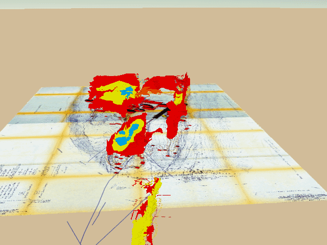
Animation of the coal veins in the West End and Stackhouse collieries on either side of the Susquehanna River near Mocanaqua and Shickshinny. The veins are color coded Red Ash (red), Ross (yellow), Baltimore (blue), and Hickory (orange). Because of the faulting, it’s likely that the Hickory vein is not a separate coal vein, but a section of Red Ash that was pushed up to the surface.
ANTHRACITE MINE POOL MAPPING FOR THE SOUTHERN AND NORTHERN COALFIELDS (2014)
EXECUTIVE SUMMARY
This report summarizes the means and methods used to map the mine pools in the Northern and Southern Anthracite Coal Fields.
Background: Since coal was first discovered in the Anthracite Region over 250 years ago, approximately 18 billion tons were removed from the Earth. This volume, not including surrounding rock that was removed to get to the coal, represents empty voids that now exist above and below ground. If these voids existed below the groundwater level, they began to flood producing vast reservoirs of water held under the ground of varying chemistries. Coal companies would pump water from the mines to continue to mine deeper into the ground. Although there were many factors that lead to the demise of underground coal mining in the Anthracite Region, one important factor was tied to simple economics: the cost to pump vs. the market value of coal. Eventually, deep mines were abandoned and the water began to fill up and discharge via mine openings to the surface. The Eastern PA Coalition for Abandoned Mine Reclamation (EPCAMR) recently completed an extensive, 4 year study and technical report, in 2011 for the Southern & Western Middle Anthracite Coal Regions, entitled, WATER QUANTITY, QUALITY, AND POTENTIAL USAGE FROM UNDERGROUND MINES IN THE ANTHRACITE REGION—WESTERN MIDDLE AND SOUTHERN FIELDS, EASTERN PENNSYLVANIA.
Purpose: This report attempts to build on previous investigations to locate and quantify large volumes of water existing in underground mine voids, known as Mine Pools, in the Southern and Northern Anthracite Coal Fields of Eastern Pennsylvania. When pairing treatment with the ability to control the amount of water coming out of the mines, large flushes of stormwater that would normally escape untreated could be retained, later treated and released in times of low water or drought conditions.
Goal: 3D Modeling of Eastern Pennsylvania Anthracite Mine Pools in Earthvision to Improve Water Quality Restoration and AMD Treatment Via Consumptive Use Mitigation Projects in the Susquehanna River Basin
Conclusions: The complex geologic setting and historical mining of the anthracite mine pools creates a challenge to calculate the volume of water stored within the underground mines. This mapping effort has reasonably found that an estimated 8,831,448,000 gallons reside in storage in 10 mines in the Southern Field and approximately 435,293,822,000 gallons in all the Northern Field. Those results are summarized below.
Southern Anthracite Coal Field (Part)
• Heckscherville Valley Mine Pools Volume Estimate: ……………………..Total ~6,268,433,000 gallons
• Rausch Creek Valley Mine Pools Volume Estimate: ………………………Total ~2,563,015,000 gallons
Northern Anthracite Coal Field (All)
• Lackawanna Valley Mine Pools Volume Estimate: ………………………Total ~160,923,304,000 gallons
• Wyoming Valley Mine Pools Volume Estimate: …………………………Total ~274,370,518,000 gallons
The full report and associated data is the property of the Susquehanna River Basin Commission, they have released it to us to provide to the public.
ANTHRACITE MINE POOL MAPPING FOR THE SOUTHERN AND NORTHERN COAL FIELDS REPORT(6MB)
Appendix A – Historic Mine Pools of the Rausch Creek Valley Southern Field (16MB)
Appendix B – Current Mine Pools of the Rausch Creek Valley Southern Field (16MB)
Appendix C – Historic Mine Pools of the Heckscherville Valley Southern Field (24MB)
Appendix D – Current Mine Pools of the Heckscherville Valley Southern Field (24MB)
Appendix E – Historic Mine Pools of the LackawannaValley Northern Field (46MB)
Appendix F – Current Mine Pools of the LackawannaValleyNorthern Field (6MB)
Appendix G – Historic Mine Pools of the WyomingValleyNorthern Field (50BMB)
Appendix H – Current Mine Pools of the WyomingValley Northern Field (50MB)
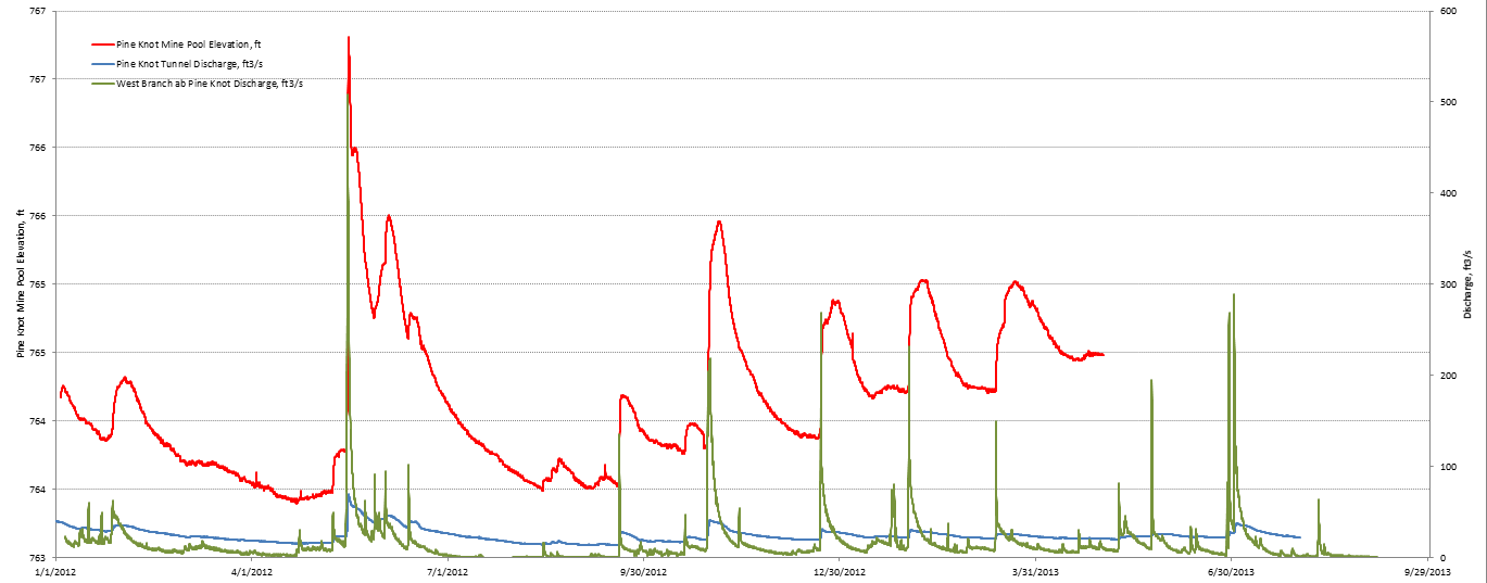
Appendix I – Pine Knot Borehole Elevations and Discharge Southern Field (41KB)
Appendix J – Lackawanna Valley Borehole Elevations Northern Field (240KB)
Appendix K – Wyoming Valley Borehole Elevations Northern Field (853KB)
Appendix L – Borehole Awareness Campaign Northern Field (619KB)
Water Quantity, Quality, and Potential Usage from Underground Mines in the Western Middle and Southern Anthracite Coal Fields of Eastern Pennsylvania (2011)
Executive Summary
 EPCAMR and a team of experts from the Pennsylvania Department of Environmental Protection’s (PA DEP) Pottsville District Mining Office and Bureau of Abandoned Mine Reclamation (BAMR), the United States Geological Survey (USGS) Pennsylvania Water Science Center, and the Office of Surface Mining (OSM) Appalachian Regional Office have been working on a 4-year study of water quantity, quality, and potential usage from underground mines in the Anthracite Coal Region. A majority of this study was funded by a Growing Greener grant from PA DEP and a grant from the Foundation for Pennsylvania Watersheds. The objective of this project is to determine the immediate and long-term availability (quantity and quality) of mine water resources in the Western Middle and Southern Anthracite Coal Fields of Eastern Pennsylvania.
 The project involves the compilation, evaluation, and synthesis of data on the hydrogeology of flooded underground coal mines. Information maintained in paper files by state and federal authorities was digitized and combined with other available data to develop a comprehensive Geographic Information System (GIS) database, containing the locations, topographic elevations, water-level elevations, flow rates, and water quality in wells, boreholes, Abandoned Mine Drainage (AMD) sources, and associated stream reaches throughout the region. Additional data on the locations of coal outcrops, barrier pillars, and mine boundaries will be included in the GIS database. This data will be evaluated to delineate horizontal and vertical boundaries in order to estimate corresponding current flooded volumes for the major mine pools, also know as Multi-Colliery Hydrogeologic Units (MCHUs). The associated recharge area(s) and primary discharge points for each of the major mine pools will be identified using digital topographic and underground mine maps and aerial photography.
 In the Western Middle Coal Field, where large pumping wells are in place and could potentially extract water from the mine pools, USGS produced a groundwater modeling report to estimate hydrologic properties including the recharge, discharge, hydraulic conductivity, and storage in the mine pools. The modeling estimates the draw-down area of influence from large pumping wells, the sustainable discharge volume (specific yield), and the potential effects on associated AMD discharge rates and stream base-flow volumes. Considering the effects of different variables (i.e., hydraulic conductivity, recharge rate, pumping rate) and corresponding outcomes (i.e., mine pool water levels, AMD flow rates, AMD chemistry), the modeling results will help guide the collection of new data in areas where adverse effects could result. That report can be accessed on the USGS webpage.
The full report is available for download below, explaining in detail the hydrogeologic characteristics of each mine pool in the Western Middle Coal Field. The results of the GIS and groundwater resource analysis will be displayed as maps in Appendix A. The results identify the quantity and quality of mine pool water. The maps will be useful to guide land-use managers as well as public and private interests concerned with water availability and economic redevelopment in Pennsylvania’s Southern and Western Middle Coal Fields. EPCAMR plans to continue this work for the Northern and Eastern Middle Coal Fields.
Mine Pool Mapping Report for the Western Middle and Southern Anthracite Coal Fields
Most files are under 5MB downloadable PDF files unless noted
Mine Water Resources of the Anthracite Coal Fields – Report (~8MB)
Appendix A – Figures, Tables, Graphs, and Maps (LARGE PDF ~330 MB)
Appendix A – Plate I – Historic Minepools of the Western Middle Coalfield (Eastern Portion)
Appendix A – Plate II – Current Minepools of the Western Middle Coalfield (Eastern Portion)
Appendix A – Plate IV – Minepools of the Western Middle Coalfield (Western Portion)
Appendix B – Notes of Mine Map Evaluation
Appendix C – Mine Drainage Water Quality Samples Inventory Database [To access the database, contact EPCAMR at (570) 371-3522]
Appendix D – Core Log of Southern Anthracite Coal Stratigraphy (LARGE PDF ~78MB)
Appendix E – Western Middle Anthracite Coal Field Borehole Data Charts (1982-2003)
Appendix F – Southern Anthracite Coal Field Shaft Data Charts (1975-1982)
Progress Reports
- Final Project Narrative Report (2011)
- 1st, 2nd & 3rd Quarter 2010 Project Narrative
- 3rd & 4th Quarter 2009 Project Narrative
- 2nd Quarter 2009 Project Narrative
- 1st Quarter 2009 Project Narrative
- 3rd & 4th Quarter 2008 Project Narrative
- 2nd Quarter 2008 Project Narrative
- 1st Quarter 2008 Project Narrative
- 4th Quarter 2007 Project Narrative


You must be logged in to post a comment.