


The Loyalsock Creek watershed is located in the Endless Mountains of Pennsylvania, which is regionally recognized as a year-round recreational area. It is locally known as “The Sock”. In reaches not affected by AMD, fishing is a major attraction to residents and tourists. Although Loyalsock Creek is designated as a Cold Water Fishery (CWF), numerous tributaries are designated as High Quality (HQ) and Exceptional Value (EV) Fisheries. According to the DEP, Bureau of Water Quality Management, designated uses are supported on all but 6 of the Loyalsock Creek’s 54 miles.
The headwaters of Loyalsock Creek is relatively unpolluted by mine drainage even though it starts in swamps underlain by a geologic formation known as the Bernice Syncline, a coal-bearing formation in the Pottsville Group. There are no major mine drainage discharges in this section, and the creek readily assimilates any minor discharges. See the map below from the Operation Scarlift Report modified by EPCAMR to show the treatment system locations.
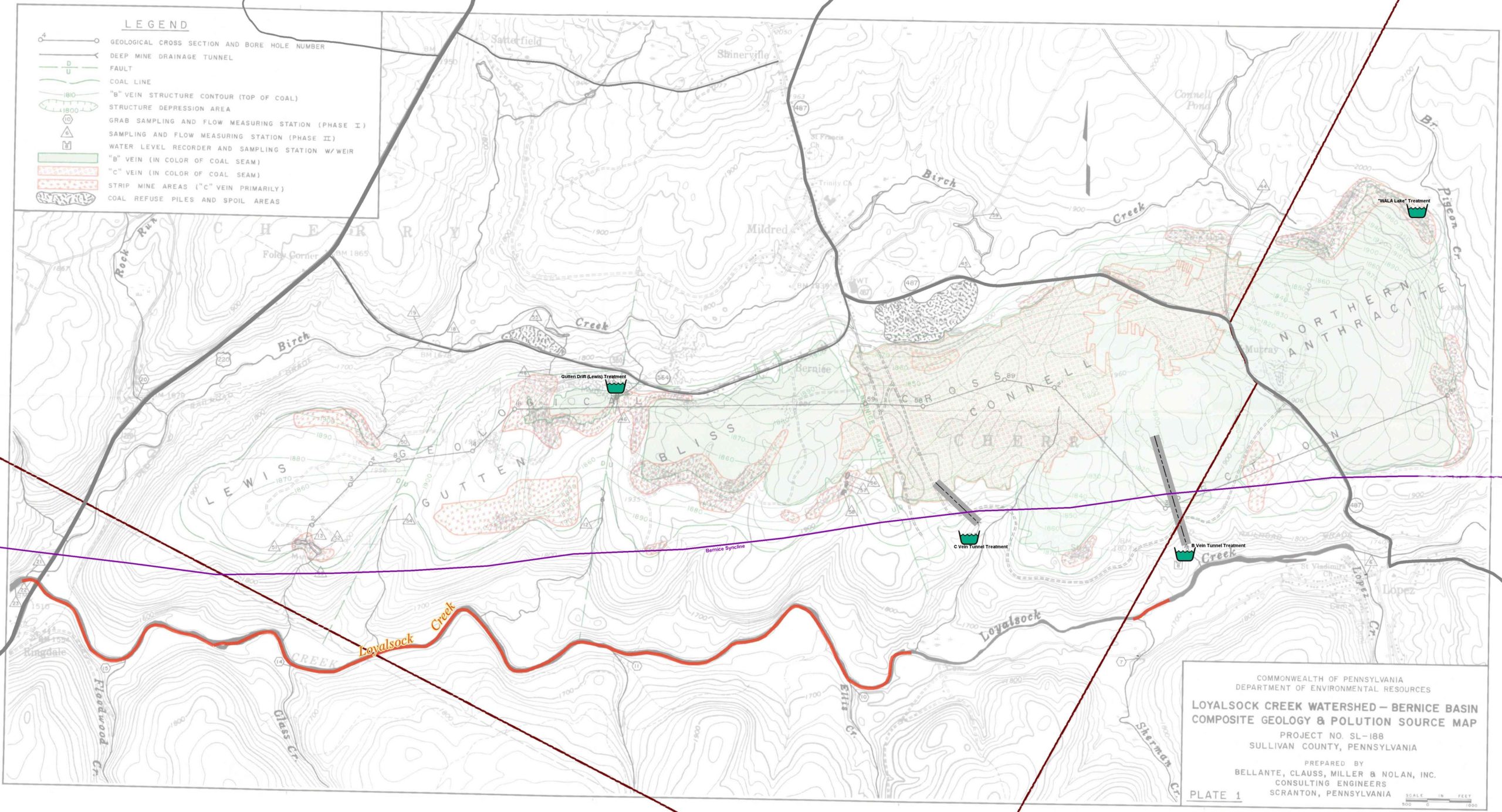
By the time the creek reaches the town of Lopez, it is hit by mining impacts in the Pigeon Creek and Long Run sub-watersheds. White Ash Land Association, who owns much of the mining-impacted lands in the headwaters of Loyalsock Creek, with the Sullivan County Conservation District and EPCAMR’s Regional Watershed Support Initiative started a project in 2001 to lime WALA lake near the headwaters of Pigeon Creek. Somewhere on the reclaimed site near WALA lake there is either a buried drift discharge or simply surface runoff from the site that is acidic and drains to the lake. The addition of limestone in the way of sand and larger rock in the “ford” crossing on the small stream that feeds the lake has boosted the alkalinity to protect the downstream fishery. See the Sullivan County Conservation District Special Projects website for more information.
As the creek passes Lopez, acid mine drainage from the Connell “B” and “C” Vein tunnel discharges enter from the mountain to the north to significantly impact Loyalsock Creek’s ability to support aquatic life. Below the discharges, the creek has reduced pH values which inhibit the survival of macroinvertebrates and some fish species. In addition to a reduced pH, episodic events cause metal concentrations to exceed in-stream limits, thereby preventing healthy macroinvertebrate and fish populations from sustaining themselves. Biological surveys conducted by the Bureau of Water Quality Management and the Bureau of Abandoned Mine Reclamation indicate degraded water quality with reduced macroinvertebrate and fish populations below the discharges. Recovery is noticeable approximately six miles downstream at Ringdale where water quality improves and macroinvertebrate and fish diversity begins to increase. From 1987 to 1990 the Bureau of Water Quality Management conducted a stream survey and found that the diversity of the fish population was significantly reduced downstream of the discharges (excerpt is taken from Loyalsock Creek Qualified Hydrologic Unit Plan in 1998).
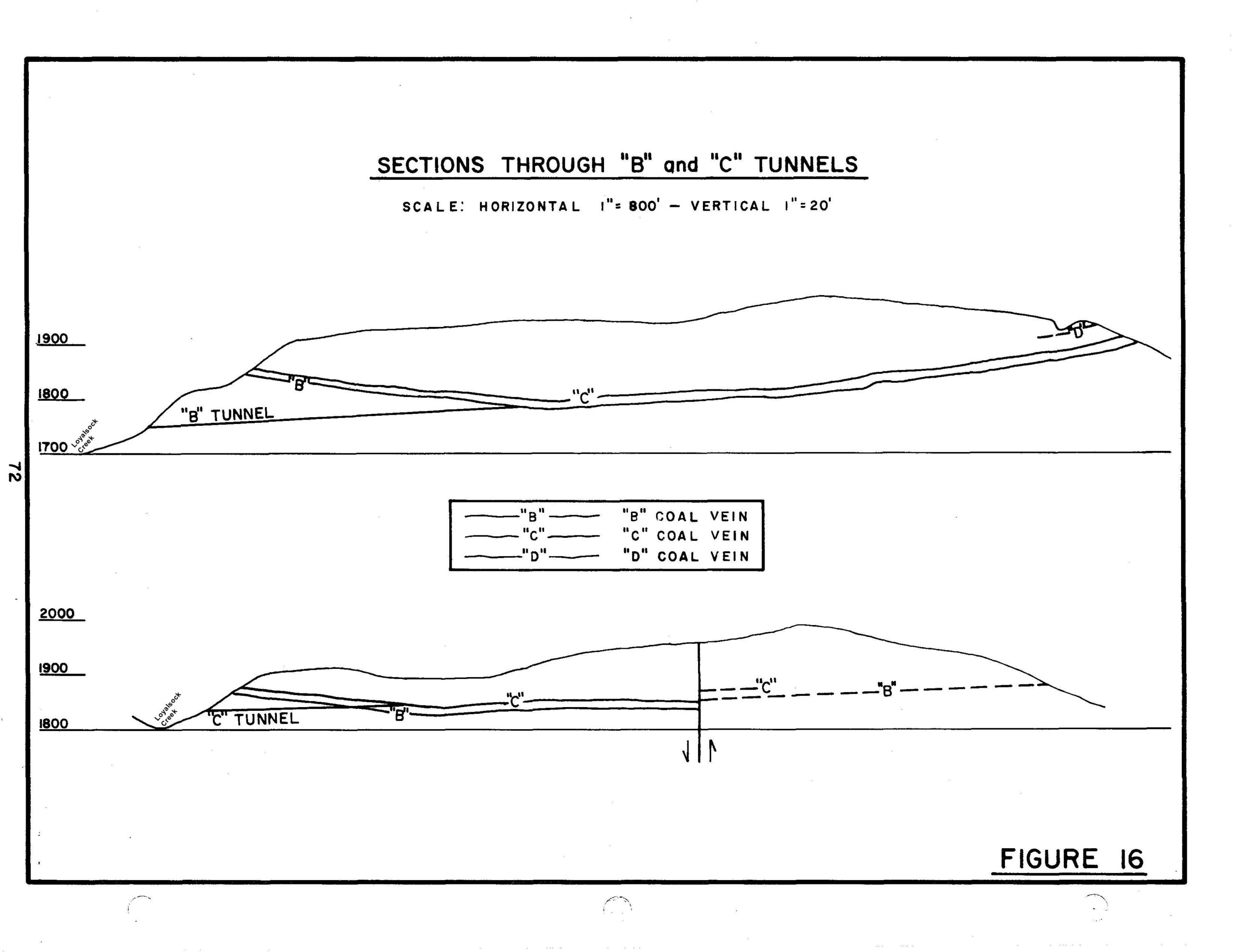
Abandoned Mine Drainage (AMD) treatment systems were placed Connell’s Tunnels B and C in the late 1990’s. The PA DEP Bureau of Abandoned Mine Reclamation (BAMR) used $227,561 of Title IV, Appalachian Clean Streams Initiative and $60,256 of AMD Set Aside Funds to create 3 Horizontal Flow Limestone Beds to treat water flowing from the Connell’s B Vein Tunnel discharge and Vertical Flow Pond (VFP) and Settling Pond to treat the water flowing from Connell’s C Vein Tunnel. PA DEP BAMR Wilkes-Barre Office monitors and maintains these 2 treatment systems. Prone to plugging, the Connell B Vein Tunnel Limestone Beds were “re-vamped” with funding from Southwest Energy in 2017. EPCAMR began monitoring the systems in 2018 – 2020. The systems showed continued metals removal and alkalinity generation but plugging remains a problem for the Connell B Vein Limestone Beds.
The Birch Creek tributary also has some mining impacts and the Guten Drift AMD Discharge which was treated by 2007. In 2016, the Vertical Flow Pond system was rehabilitated by EPCAMR to re-establish a compost layer, “fluff” the limestone and add a flush basin to catch solids before they reach Birch Creek.
Loyalsock Creek Qualified Hydrologic Unit Plan – documentation of AML problems that qualify the watershed for funding set-aside by the state from the AML Trust Fund (federal AML cleanup funding created SMCRA).
Operation SCARLIFT Report – a report completed by the state in the 1970s to determine the scope of environmental problems in the watershed and potentially how to fix them.
Loyalsock Creek TMDL Report – an assessment of the Loyalsock Creek with emphasis on polluted sections and a total maximum daily load of pollution that the stream can handle.
Facebook Album: Loyalsock Creek: Lewis AMD Treatment System[fbphotos id=10151854242264095 rand=1 limit=8]


You must be logged in to post a comment.