


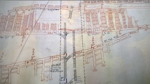
EPCAMR GIS Specialist, Samantha Schafer, and Watershed Outreach Specialist, Gabby Zawacki, along with other GIS staff members, Kelsey Biondo and Dave Svab, are working to design and produce a quick reference Mine Map Symbol poster of common and not so common mine map symbols, geologic points of interest, and surface and underground features from Northeastern and North Central Pennsylvania Anthracite coal mine maps. Over the last several months, the GIS Department of EPCAMR has found and deciphered many types of mine map symbols from surface, underground mine, and cross-section maps, as a part of the Commonwealth’s Mine Subsidence Insurance Program, through the scanning, cataloging, geo-referencing, and digitizing of thousands of mine maps.
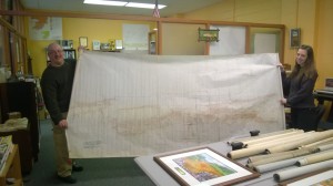
Robert and Kelsey holding up a map of the Holmes vein; it’s nearly 20′ long!
EPCAMR Executive Director, Robert Hughes, tasked Samantha, following her recent evaluation and promotion, with creating a poster of the many mine map symbols that she and other staff have come across over the past year or so. She picked up quickly on some graphics design software tools and shortcuts, thanks to Gabby’s design knowledge. “I wanted her to be able to take the mine map symbols and create a quick reference guide, not only for the EPCAMR staff, but also for the general public (mining enthusiasts, preservationists, future interns, and the like). I wanted to produce it as a public service to those who may own old mine maps and don’t understand how to interpret them. My co-worker, Mike Hewitt, and I were trained by some of the best mining engineers in the Pennsylvania over the last few decades, and for this knowledge, we are forever thankful. There are many Anthracite mining company secrets, including proprietary use of symbols and mining terms (i.e., the same coal vein spanning across these mines having different names in each company). EPCAMR is now deciphering some of those ‘Anthracite Hieroglyphics,’ as I like to call them. The EPCAMR staff did a great job and public service by putting this quick little reference guide together.”
The EPCAMR staff can create digital points on the maps’ surface to locate these mining features within a geographic space and give them a latitude and longitude in terms of global positioning. The location then allows us to obtain a topographic elevation of the surface in order to make a determination of depth, such as to water levels, tunnels, drifts, slopes, shafts, gangways, and faults, among others.
This is an underground mine map of the Holmes Vein within the Silver Creek Colliery in Blythe Twp., PA.
Water elevations in the boreholes help us estimate volumes of water present in the underground mine pools and points underground at which mine water flows around, over, and sometimes through barrier pillars as it makes its way to the surface and discharges as abandoned mine drainage. We believe that much of the symbology is the same for the Bituminous Region of Western Pennsylvania, so the poster may prove useful to our counterparts like WPCAMR and Trout Unlimited, to assist them in interpreting the intricacies of underground mine mapping. EPCAMR is sure to find many more of these symbols as we continue to work through the thousands of maps that have yet to be processed. We may add another poster to this as a series if there prove to be more symbols.
EPCAMR provides this image online for free, however, should anyone want a paper copy of the poster mailed directly to them, it is available for order at the EPCAMR Online Store for a minimal processing fee.

EPCAMR Mine Map Symbology poster
Mine Map Symbology Poster (PDF Download)
EPCAMR is also looking for mine maps to add to our digital collection, which can then be provided to the state to upload to the Mine Subsidence Insurance Program website for public viewing. We will scan them and provide a digital copy back to the owners of the maps for free as a public service.
Should anyone have a collection in their homes and don’t know what to do with them, EPCAMR will take them as a donation or will scan them digitally for you and give them back. Contact Robert Hughes at (570) 371-3523 or rhughes@epcamr.org.


You must be logged in to post a comment.