


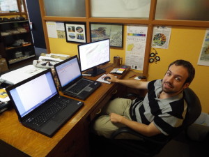
Paul Dunay III, EPCAMR’s newest Staff member working on 3 screens on his first day as our GIS Technician under our recently funded Mine Map Grant
EPCAMR is proud to announce that one of several positions has been filled part-time internship, by Paul P. Dunay III, as a GIS Technician to assist us with beginning to process mine maps and other mine related information into electronic formats and 3D images. The project that EPCAMR is working on with the Commonwealth of PA is to process information that is either owned or under the control of the PA Department of Environmental Protection (PA DEP), EPCAMR, or form private coal company or other collections. As a result of work that will be done by Paul and other interns, processed mining information will be available for use in computer systems that allow the information to be provided to the public in a fraction of the time it takes to provide them with unprocessed information that should have been made available to the public many years ago. The processed information can be used by property owners and developers, by EPCAMR for our own purposes in mapping the Anthracite Coal Region’s underground mining areas and mine pool complexes, and by the PA DEP to further enhance the electronic systems that deliver mining information and abandoned mine information to the public to contribute to safe and economic mining practices as well as more informed decisions on where to locate, build, or buy a home or business, for instance. In addition, the work that Paul and other EPCAMR Staff will be doing for the next 3 years, the information in electronic form establishes permanent records that will not deteriorate over time, that can be further processed and stored without the need for costly filing and warehousing.
EPCAMR is the ONLY non-profit regional environmental organization in PA to recently receive a 3 year Mine Map Grant in the amount of $342,143 to hire 3-4 additional part-time interns that have already been working with EPCAMR over the last several years who were working on other Geographic Information Systems (GIS) and abandoned mine related projects and work that are experienced, proficient, and are now going to have the opportunity to work nearly full-time, up to 30-35 hours/week. Two more GIS Technicians are expected to be hired by the Fall of 2013 and a GIS Specialist will expand EPCAMR’s organizational capacity to fulfill the grant obligations of scanning, geo-referencing, and digitizing historic mine maps and other image files need to be archived and converted to a digital and electronic medium. 9 other Major Universities and Colleges across PA received a grant in this first round of funding. EPCAMR has put itself in a very unique position as a State-wide leader and has the expertise in the interpretation of underground mine maps, mapping underground coal measures and mine pools, and has over 22 years experience in the reclamation of abandoned mine lands and the remediation of abandoned mine drainage (AMD) across PA. EPCAMR will be undertaking the complex assignments of scanning, geo-referencing, and digitizing mine maps and images from the Pottsville District Mining Office, the Wilkes-Barre PA DEP’s Bureua of Abandoned Mine Reclamation (BAMR), EPCAMR’s own private collection, and are going to be working in partnership with the Earth Conservancy, to see if they would like us to bring in their mine map collection at a much higher resolution than they currently have for the Blue Coal Corporation’s collection that is housed in the same Office Building as EPCAMR.
“Mining information is needed by the residents and developers of the mining regions of PA to make informed decisions whenever a house or building is built or purchased, when roads, schools, or other public facilities are constructed, AMD treatment systems are constructed, or when mining and reclamation operations are conducted. The information is vital to the economic activity and vitality of PA and to the public health and safety of the residents of the mining regions and those working in or visiting these areas,” Robert Hughes, EPCAMR Executive Director emphatically stated. “Here in the Anthracite Region, particularly with the closure of the Federal Office of Surface Mining’s NE Regional Headquarters that used to be located in the Stegmaier Building, in Wilkes-Barre, where the original mine map folios and other related historic archival information used to be housed for the public to view, EPCAMR felt that we had a niche and obligation to continue to dig a little deeper into our work in the Region and propose to continue to do this type of technical assistance for our mining communities as a public service, fulfilling our mission and goals of our organization.” he stated with a passion. Special State funds are financing the Mine Map Grant under the authority of the PA Surface Mining Conservation and Reclamation Act, the Bituminous Coal Mine Safety Act, and the Mine Subsidence Fund regulations set forth at 25 PA. Code Section 401.51. Details about the programs within the Commonwealth of PA that will utilize the information that EPCAMR will be providing can be found at www.pamsi.org
Paul is a 2009 graduate of Tunkhannock High School in Wyoming County and a recent May 2013 Keystone College graduate with a Bachelor’s of Science in Environmental Biology with an interest in GIS. His previous internship experience was with the Susquehanna County Conservation District, a partner in the EPCAMR region conducting Administrative reviews of Erosion & Sedimentation Control Plans, conducting site inspections and field investigations, and with the PA Fish & Boat Commission, where he used GIS to locate the mouth of tributaries to identify private property owners to seek permission to access the streams to conduct electro-shocking and fishery population data under the Unassessed Waters Initiative. He has tutored students as well as taught GIS labs first as volunteer tutor and then eventually became a paid GIS Instructor at Keystone College. He has experience in applied GIS techniques to create interactive web maps and is very proficient in ArcGIS v9.3 to 10.1.
Robert stated, “This previous experience is going to allow Paul to jump right into the scanning and geo-referencing of the mine maps with very little training needed and that is a bonus for EPCAMR. One thing that I look at right off the top when a resume is submitted looking for internships or work is what previous internship experience or work experience does a person have in the areas that we need. If they don’t have that experience, the resume gets moved down the pile a little further, while others like Paul’s floats to the top. This is yet another reason why obtaining internship experiences early in one’s collegiate career is vitally important. Don’t look at the internship for how much of a stipend you will get, look at in terms of how much first hand experience and knowledge will one gain that will make you more competitive and stand out among those around you that are also looking for the same opportunity.” Paul’s other hobbies and interests are in computers, obviously, playing the guitar, and he is a Black Belt Instructor in Martial Arts. Robert jokes, “At least, we know that if the EPCAMR Staff is in the field and are approached by, let’s say a black bear, that we can count on Paul to be our safety guy and allow him to confront the bear first in his defensive fighting stance while Mike and I play dead.”
“Doing GIS is one of my favorite things to do. Even though it is only considered a tool, I find it to be much more than that. I like to look at it from a deeper perspective. I was attracted by the GIS work EPCAMR was doing in the Lackawanna Valley trying to decode and map the underground mine pools that were associated with the Scranton-Metro Mine Pool Complex. The 3D mine mapping project allows me to use my skills in GIS to help PA Coalfield communities, map, and clean up the rivers and streams impacted by AMD. AMD is a serious problem in our area and I want to become a local part of the solution and keep my talents in this region. The work in GIS that Robert and Mike, along with the other interns at EPCAMR is excellent and not being done by anyone else with the level of technical expertise and knowledge that these guys have. I want to add to that knowledge base as well as absorb some of that institutional knowledge that this reputable and respectable regional non-profit has to offer to increase my level of understanding of the mining region of Northeastern and NorthCentral PA, where I grew up and now have been giving an opportunity to become a part of the solution.” Paul stated with a sense of excitement on his face.


You must be logged in to post a comment.